A hurricane does not begin with wind. It begins with a transfer, the quiet movement of energy from a warm ocean into the air above it. On the surface, it looks almost ordinary: sunlight warms tropical water, and that warmth encourages evaporation. Molecules of water escape into the atmosphere as invisible vapor, turning the lowest layer of air into something lighter, wetter, and more eager to rise. This is the first place hurricanes get their strength, not from a dramatic moment on the weather map, but from the steady generosity of warm seas giving up heat and moisture hour after hour.
That warmth has a practical threshold. Hurricanes are most likely to form and intensify over ocean water that is roughly 26.5°C or warmer, and it helps when that warmth is not skin deep. If the warm layer extends down through a meaningful depth, the storm has a larger “bank account” of heat to draw from. This matters because hurricanes stir the ocean as they pass. If cooler water is easily pulled up from below, the surface chills and the storm’s fuel supply weakens. If the warm water reaches deeper, the storm can keep extracting energy even while it churns the sea beneath it. In other words, part of hurricane strength is not just how warm the water is today, but how much warm water there is to borrow from when the storm starts spending.
Evaporation, however, is only the opening act. The real power shows up when that water vapor rises and changes state. Warm, humid air is buoyant, so it lifts upward in tall, growing thunderstorms. As it rises, it cools, and the water vapor begins to condense into cloud droplets and rain. That condensation releases latent heat, energy that was stored invisibly in the vapor and is returned to the surrounding air when the vapor becomes liquid. This release is the crucial conversion that makes hurricanes more than just rainstorms. Latent heat warms the air in the storm’s core, and warmer air rises more readily, which encourages stronger updrafts, which encourages more condensation, which releases more heat. It is a reinforcing loop, and it is one of the clearest answers to the question of where hurricanes get their strength: they get it from the physics of phase change, moisture turning into rain and giving back the energy it carried.
Once that loop starts to organize, a hurricane behaves less like a random cluster of thunderstorms and more like a disciplined engine. One of the most useful ways to picture it is as a heat engine operating between two reservoirs. The warm ocean acts like a hot source, and the upper atmosphere acts like a cooler destination where heat can be carried away. The hurricane’s circulation is the mechanism that moves energy from the ocean surface upward and outward. Air spirals in near the surface, picks up moisture and heat, rises in the storm’s core as thunderstorms fire, and then spreads outward aloft like an exhaust system, exporting heat to the colder air at higher altitudes. The storm’s winds are not the cause of this energy flow so much as the outcome of it. Stronger heat transfer supports lower central pressure, and a deeper pressure drop supports faster winds. The wind, in turn, boosts evaporation and strengthens the very process that created it. The hurricane intensifies when that engine runs efficiently.
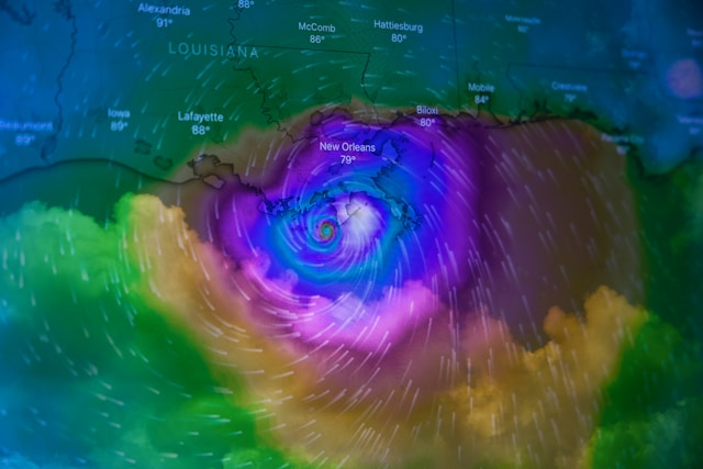
This is where the hurricane’s famous structure matters. The eye and the eyewall are not just dramatic features on a satellite image. They are a functional arrangement that helps the storm concentrate and recycle energy. The eyewall, the ring of towering thunderstorms around the calm center, is where the most intense rising motion tends to occur and where the most latent heat is released. It is the storm’s busiest zone, the place where warm, moist air is converted into cloud, rain, and heat most aggressively. The eye, by contrast, tends to be calmer because air is sinking there rather than rising. That sinking motion can warm and dry the air, helping maintain the clear pocket at the center. The effect is a storm that knows where to put its most powerful processes, like a system that has learned how to focus effort instead of wasting it everywhere.
Rotation plays a supporting role in this organization. Hurricanes need Earth’s rotation to help them develop a coherent spin, but spin is not the same as strength. Rotation becomes valuable because it helps maintain a stable center and allows air to spiral inward rather than rush straight into the low pressure and fill it immediately. A spinning system can sustain a pressure gradient and keep drawing new warm, humid air toward its core, which keeps the heat engine supplied. Without that organized circulation, thunderstorms might still flare, but they often collapse or drift, and the storm struggles to maintain a tight, self-reinforcing structure. Rotation is the framework; heat and moisture are the fuel.
If you want to understand why hurricanes can suddenly jump in intensity, it helps to look at what makes the engine unusually efficient. Rapid intensification is not magic. It is often what happens when several favorable conditions align at once: very warm water, a deep warm layer, abundant atmospheric moisture, low vertical wind shear, and a storm structure that is already becoming organized. Wind shear refers to changes in wind speed or direction with height. When shear is strong, it can tilt the storm, disrupt its vertical alignment, and separate the strongest thunderstorms from the center where they do the most good. A hurricane strengthens most easily when the atmosphere above it is cooperative, allowing the system to stay stacked and symmetrical, so that the heat released in thunderstorms is centered over the low-pressure core. That alignment keeps the feedback loop tight: more convection deepens the pressure fall, a deeper pressure fall strengthens the winds, stronger winds increase evaporation, and greater evaporation feeds even more convection.
Moisture in the surrounding environment also matters because dry air can act like a suppressor. When dry air intrudes into the storm, it can weaken thunderstorms by encouraging evaporation and cooling within clouds, which reduces the sustained upward motion the hurricane needs. A storm that cannot keep thunderstorms firing in the right place cannot keep releasing latent heat where it most effectively lowers pressure. Strength, in this sense, is not only about how much energy is available, but also about whether the storm can protect its core processes from disruption.
The hurricane’s exhaust system is another quiet contributor. Rising air has to go somewhere. If air piles up at the top of the storm because outflow is restricted, the system becomes less efficient, like an engine with a clogged vent. Good outflow allows air to diverge away from the center aloft, which supports rising motion below. Strong rising motion supports vigorous condensation and latent heat release, and that supports a deeper low-pressure center. When you see a hurricane with clean, expansive outflow on satellite imagery, you are often seeing an engine that is breathing properly.
Just as certain conditions help a hurricane gain strength, others steal it by breaking the loop or draining the energy supply. Land is the most obvious thief. Once a hurricane moves over land, it loses the warm ocean surface that supplies heat and moisture. Friction also increases, which slows the winds and disrupts the low-level inflow. Without steady evaporation and organized inflow, thunderstorms weaken, latent heat release declines, pressure rises, and the system begins to unwind. Cooler water can have a similar effect at sea. If a hurricane crosses colder waters, evaporation decreases, the atmosphere becomes less moist, and the storm loses its primary fuel.
Wind shear, again, is a common disruptor, especially when a storm is trying to intensify. Shear can push thunderstorms away from the center, exposing the circulation and making it harder for the storm to maintain a warm, low-pressure core. Dry air intrusion can weaken convection in a similar way, sometimes causing the storm to fluctuate as it struggles to keep its central thunderstorms alive. Even internal changes can temporarily reduce strength. Hurricanes can go through structural transitions that change their peak winds for a period, such as when a new eyewall forms farther out and replaces the old one. These shifts can make a storm appear to weaken and then re-strengthen, not because the ocean suddenly cooled, but because the storm is reorganizing the machinery that converts heat into wind.
All of this can sound technical, but the underlying story is remarkably consistent. Hurricanes get their strength from energy that starts in warm ocean water. That energy is carried upward as moisture and released as latent heat when water vapor condenses into clouds and rain. That heat helps lower pressure and sustain rising motion, and the pressure difference drives stronger winds. Those winds increase evaporation and feed the cycle again. A hurricane becomes powerful when it can keep this feedback loop running smoothly, with minimal interference from wind shear, dry air, land, or cold water. It is not brute force so much as an efficient, self-reinforcing system that turns heat into motion.
There is also a useful emotional comfort in understanding hurricanes this way. A hurricane can feel like pure chaos when you are watching it on a screen or bracing for it on the ground, but its strength follows inputs and constraints. Warm water, moisture, and a cooperative atmosphere are the ingredients. Disrupt the alignment, reduce the moisture supply, cool the water, or increase wind shear, and the storm’s ability to intensify declines. The hurricane is powerful, but it is not limitless. Its strength is borrowed, converted, and maintained only as long as the environment keeps paying into the energy loop that sustains it.


.jpg&w=3840&q=75)

